|
Follow the Gold Rush to Alaska and The Yukon
Follow the Gold Rush to Alaska
and The Yukon
|

|
|
Driving in our specially equipped, satellite linked expedition vehicle our team explored the natural environment and cultures of the far north for five weeks beginning on May 6, 2002.
View the tremendous diversity of animal and bird life, explore the abandoned ghost towns left behind by the gold miners after the lure of riches panned out, learn about the culture and visit the traditional homelands of the native people who have made this region their home since crossing the Bering land bridge thousands of years ago.
Explore the National Parks and the UNESCO World Heritage Sites that preserve the beauty of the region. Follow the links below to start your own expedition.
|
|
Geography and Climate
Size
Mountains
Rivers
Glaciers
Geographic Regions
|
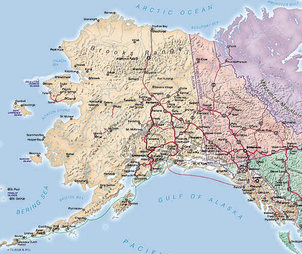
The state of Alaska covers 570,374 square miles (1,477,267 sq km) and is the largest U.S. state. It is almost twice the size of Texas, the second largest state. Its geographic center is located approximately 60 miles (96 km) NW of Mt. McKinley. It has 6,640 miles of coastline and including islands, has 33,904 miles of shoreline.
Alaska is bordered on three sides by water. To the north is the Arctic Ocean, to the West is the Bering Sea and to the south are the Gulf of Alaska and the Pacific Ocean. To the east are Canada and the only roads connecting Alaska with the rest of the United States.
Mt. McKinley at 20,320 feet (6,096 mt) is the tallest peak in Alaska. It is also the tallest peak in North America. Of the 20 highest peaks in the U.S., 17 of them are in Alaska. The highest point in Canada is Mt. Logan in the Yukon. It is 19,850 feet (5955 mts) high. Mt. Logan is the largest mountain massif in the world. It rises nearly from sea level and has a base nearly 100 miles in diameter. Compare this to Mt. Everest, which rises to 27,000 feet (8100 mts), but starts from a plateau at nearly 20,000 feet and you can visualize the magnitude of Mt. Logan's size.
The Yukon River is the longest river in Alaska and the Yukon at 1,875 miles long (3,019 km) and is the third longest river in the U.S. There are over 3,000 rivers in Alaska and over 3 million lakes.
There are an estimated 100,000 glaciers in Alaska. The largest is Malaspina at 850 square miles. Glaciers cover five percent of the state, or 29,000 square miles. The speed at which the glaciers in Alaska are melting is increasing at a faster pace than previously thought. Read more here.
Alaska can be split into several geographic regions:
The southeast of Alaska is comprised of a 500-mile coastal strip containing hundreds of islands, stretching from north of Prince Rupert in British Columbia to the Gulf of Alaska. On the inland side of the strip is the Pacific Mountain System consisting of the Saint Elias Range, the Wrangle Mountains, the Chugach Mountains and the Kenai Mountains. Winding its way through the islands is the Inside Passage waterway. Also known as the Alaska Marine Highway, many towns and cities are served by the ferries that ply these waters as there few roads. The mountain ranges, glaciers and fjords that crisscross the area prohibit road building.
The south central region includes Prince William Sound and the Kenai Peninsula. The Pacific Mountain System continues west through this area and runs all the way to the Aleutian Islands. This area has a mixture of mountains, glaciers, fjords and forests.
The southwest region stretches 1,500 miles from Kodiak Island in the Gulf of Alaska to the International Date Line and includes the Alaska Peninsula, the Aleutian Islands and Bristol Bay. The mountain range through this area is a continuation of the Alaskan Range in the interior and continues into the Aleutian Mountain Range. This region also contains the Pacific Ocean�s Ring of Fire and contains 46 active volcanoes, more than any other region in North America.
The Central Uplands and Lowlands make up the largest land area in Alaska. This area has three major roads that cut across the center of the state and provide access to a number of forests, parks and recreational areas including Alaska�s most noted destination, Denali National Park and Preserve. Sandwiched between Denali and the Rocky Mountain Range to the North, low rolling hills and swampy river valleys such as those of the Yukon River run west toward the Seward Peninsula and the Kuskokwim River area.
The Artic Coastal Plain is the northernmost geographic area of Alaska. It lies north of the Rocky Mountain System and slopes gradually toward the Arctic Ocean. This is the land of permafrost (permanently frozen ground) and trees won�t grow here. In the spring however the ground does thaw enough to support grass and wildflowers.
June 21st marks the beginning of summer in the Northern Hemisphere and the beginning of winter in the Southern Hemisphere. In the North it's the longest day of the year. Above the Arctic Circle the sun doesn't set at all! On December 22nd the long night is just reaching its midpoint. The temperature there can reach a frigid -57 deg. C and the sun won't rise again for 3 months. Check out this NASA Science page for more details.
What is the weather like today in the far north? Follow these links for Alaska and the Yukon
Try converting the temperature in your town from Fahrenheit to Celsius.
What time is it in Alaska as compared to the time in your home town? Check this!
|
|
Top of Page
|
|
History
First Nation tribes
Europeans
Russians
US Americans
ALCAN Highway
|
First Nation Tribes
The first Alaskans migrated from Asia across the Bering land bridge (today called Beringia) between 30,000 and 40,000 years ago. Although many different tribes crossed over from Siberia only four ethnic groups became permanent residents: the Athabascans, the Haida & the Tlingit, the Inuit and the Aleuts. These First Nation tribes believe the Raven created the world. (Learn more about these people in the Ethnic Groups and Culture section.)
European
The first known European to visit Alaskan waters was Bartholome de Fonte in 1640. He sailed up from Mexico along the west coast and explored the network of rivers looking for the Northwest Passage, a route between the Pacific and Atlantic oceans. He was followed by Vitus Bering in 1728, a Danish navigator who wrote the first written record of Alaska. Thirteen years later, on a second trip, he became the first European to set foot on Alaska. Though he and most of his crew died from scurvy on the trip, the survivors returned with animal pelts and stories of plentiful otter and seal colonies. Russians soon set up a settlement on Kodiak Island to cash in on the fur trade.
Russians
The Russians were the first to exploit the natural resources of Alaska. They were primarily fur trappers and traders and they rarely ventured inland. They were so successful that they nearly depleted the region of all fur bearing animals. In addition they were brutal to the coastal indigenous people, treating them as slaves.
The British arrived in 1778 when Captain James Cook also began searching the area for the Northwest Passage. In 1786 the French arrived and made it as far as Lituya Bay on the southern coast of Alaska before being done in by the devastating tides in the bay. Twenty-one sailors were killed and the French decided against any further exploration in the area. Captain Cook�s shipmate George Vancouver later returned to chart the Inside Passage, producing maps so accurate they were still being used a century later.
US Americans
By 1860 Russia�s funding for the declining fur trade was running out. They approached the United States to interest them in the purchase of the territory, but it wasn�t until 1867 that Secretary of State William H. Seward signed a treaty to purchase Alaska for $7.2 million dollars, which was less than 2 cents an acre. Called "Seward�s Folly", the American public was upset over the purchase and the fight in the Senate to ratify the treaty lasted six months.
Slowly, but surely, however, Alaska�s bounties were being discovered. First it was whaling in the southeast and the Bering Sea, and then it was the tremendous salmon runs in the Alaskan rivers that brought about the first canneries in 1878.
But it was gold that really brought people to Alaska. Gold was first discovered in the Gastineau Channel in the 1880�s while in the interior it was discovered in 1893. But it was in 1896 that the Klondike gold rush in Canada�s Yukon Territory really brought people to Alaska.
Occurring during a worldwide recession, the Klondike gold rush brought thousands of people to Alaska in search of riches. While only a few actually made a fortune, towns such as Skagway sprang up overnight to tend to the needs of the thousands who came through town needing supplies. 30,000 people passed through Skagway and Dyea, over the steep Chilkoot Trail and White Pass and across Lake Bennett on their way to the gold fields. Read about the Klondike Gold Rush here.
Read about the stern-wheel boats that brought many to the Klondike and the gold-dredges that were used to mine the gold from the riverbeds.
So many people arrived in Alaska over the next 10 years that they wanted more of a say in their government. So in 1913 the territory presented its first statehood bill to Congress. World War I intervened however and when many Alaskans left the state to fight the war, the statehood issue was set aside.
ALCAN Highway
It wasn�t until World War II and the threat of a Japanese landing that the government finally took note of Alaska. Large army and air force bases were built to protect the U.S.�s investment but more importantly, the Alaskan Highway was built. Begun in February 1942, the 1,520 mile long Alcan (as it is popularly called) was finished 8 months later. A major engineering feat, over 10,000 troops took part in its construction. One-third of these troops were African-Americans who were prohibited from serving their country in combat roles. Living in canvas tents and surviving temperatures as low as -75 degrees F, these workers toiled to complete a road that would one day be compared to the Panama Canal. View this link to the 95th Engineer Regiment - Colored. To view a copy of the video African Americans in World War II: A Legacy of Patriotism and Valor view this link.
The completion of the road and its opening to the public in 1948 led to further growth in the territory and a new drive for statehood. A bill was presented in 1958 and this time approval came swiftly. On January 3, 1959, Alaska was declared the 49th state.
In 1968 oil was discovered in Prudhoe Bay. With the building of the 789-mile Alaskan pipeline, thousands of jobs were created and towns such as Anchorage and Fairbanks have become large modern cities. More recently tourism has become a large and important industry.
|
|
Top of Page
|
|
Prehistoric Alaska
|
Depending on what part of Alaska you visit, you can find fossils of marine invertebrates from the distant Paleozoic Era, Dinosaurs from the Cretaceous Period, or Ice Age mammals that disappeared just yesterday (in relative terms).
Much of Alaska is permafrost. This is soil that is frozen year round. Therefore, it is not easy digging up fossils in Alaska. But other fossils are found lying on the surface here and there in upland areas and along coasts. Fossils of marine invertebrates, such as clams and snails, can be found on mountains north of the Arctic Circle, for example. Similar fossils are found in island cliffs in south-central Alaska.
Alaska is special because of its geographic position as North America's closest point to Asia. During the Pleistocene Epoch ("Ice Age"), much of Earth's water was stored in great continental glaciers. This caused the sea level to fall dramatically, exposing dry land between Alaska and Asia, thus linking the New World (North and South America) with the Old World (Eurasia and Africa).
Although it's often described as a "land bridge," this area of new land actually covered a vast area which scientists call Beringia. Check out the information at the Yukon Beringia Interpretive Centre.
Many species of plants and animals crossed over the Bering "land bridge." Porcupines evolved in South America, then spread into North America when those two continents were united. Next, they crossed the Bering Land Bridge and spread across Eurasia and Africa! Horses evolved in North America, where they later became extinct, for reasons no one knows. But before they died out in the New World, horses had crossed into the Old World. Many thousands of years later, European explorers brought horses back to North America. Thus, horses wouldn't exist if not for the Bering Land Bridge!
Old World animals that crossed the Bering Land Bridge into North America included lions, cheetahs and musk oxen. Of course, the most important immigrants were humans, who entered North America more than 10,000 years ago.
Remains of woolly mammoths, long-horned bison, horses, and other Ice Age creatures are commonly found when people excavate buildings or roads. Gold miners sometimes use powerful hydraulic hoses to blast through permafrost in their search for riches. Such operations uncover countless fossils.
For more detail, check out the Archaeological Overview by the National Park Service
|
|
Top of Page
|
|
Ethnic Groups and Culture
|
Alaska�s population is 622,000 (August 2000). Nearly half of the state�s residents live in Anchorage. Alaska has .93 square miles for each person in the state. By comparison, New York has .003 square miles per person.
Today Alaska Natives represent approximately 16 percent of Alaska's residents, and are a significant segment of the population in over 200 rural villages and communities. Many Alaska Natives have retained their customs, language, hunting and fishing practices and ways of living since "the creation times."
Alaska's Native people are divided into eleven distinct cultures, speaking twenty different languages.
� Athabascans
� Yup'ik & Cup'ik
� Inupiaq & St. Lawrence Island Yupik
� Aleut & Alutiiq
� Eyak, Tlingit, Haida & Tsimshian
Anthropologists believe that the original Native peoples crossed from Siberia to North America over the Bering land bridge that connected the two continents. However, we need to be aware that the Alaska Natives have their own belief system about their origins. They have their own creation stories that are taught from generation to generation about who they are.
For more detailed information on the Native Cultures follow this link to the Alaska's Native Cultures Page.
Some native traditions are being threaten for political reasons. Read here how the Eskimos have lost the right to their traditional hunt of a limited number of Bowhead whales. "Loss of Hunt Stings Eskimos."
For examples of Native Lore, click here.
|
|
Top of Page
|
|
Fauna and Flora
|
The north has an amazing variety of fauna. There are moose, black bears, grizzly bears, brown bears, Dall sheep, stone sheep, mountain goats, wolves, foxes, beavers, deer, elk, caribou and a large number of smaller animals. The lakes and rivers are full of salmon, sockeye, Dolly Varden, grayling, char and trout. There are more than 400 species of birds: puffins, cranes, geese, ducks, ravens, magpies and eagles. In the ocean there are whales: humpbacks, grays, minke fin and belugas. There are porpoises, orcas, seals, sea lions and otters.
Although not considered as fauna, bugs such as the mosquitoes and no-see-ums are considered by many to be a bigger threat to a person's sanity than the big animals such as bears or moose.
| There are 27 species of mosquitoes just waiting to bite something. |
 |
See pictures of the animals that live in the Far North. Check these links: Arctic Wildlife Portfolio, Alaska Dept of Fish & Game.
Some of the more common trees and plants in Alaska and the Yukon are:
The Sitka spruce, the Alaska state tree. This tree is recognized by its stiff, sharp-tipped needles. Spruce is important commercially and is harvested throughout southeast Alaska . Forestry is only a small industry in the Yukon with only 15 percent of the land considered commercially productive. It is used in airplane construction among other things. In World War II, Howard Hughes built the Spruce Goose. Evergreen Aviation Museum.
Western hemlock is recognized by its short, round-tipped needles. It is primarily used for producing high-grade pulp for the manufacture of cellophane and rayon. It is also used for lumber and plywood.
Cedars can be identified by their flattened needles. The western red cedar is widely used for shingles. It is also the wood of choice for totem poles and canoes made by native people. Alaska cedar is used for window frames, doors and boats.
Red alder is the most abundant broadleaf tree. It can be recognized by its smooth bark with horizontal lines and its deep green wide-toothed leaves. It can be found along streams and near beaches. It is used for smoking meats and fish.
The Yukon's vegetation can be classified as sub-arctic and alpine. Boreal forests cover 57 per cent of the territory. White spruce, black spruce, lodgepole pine, tamarack, aspen and balsam poplar are the most common tree species. Follow this link for more details on the species that live in this region, Boreal Forest Library. More than 200 species of wildflowers are found in the Yukon. They include anemones, yellow potentilla, monkshood, arctic poppy, harebell, wild rose, lupines, lousewort, wintergreen (pyrola) and beardtongue (penstemon). One of the most commonly seen flowers is the tall magenta fireweed, the Yukon's official flower. It lines the roads and covers burn areas throughout the territory in July and August. Alpine areas are dotted with moss campions, wild forget-me-nots and mountain avens. Orchids include the white bog orchid, ladies tresses and the round leaf orchid.
Berry bushes such as salmonberry, huckleberry, blueberry and bunchberry are abundant and provide forage for bears. Flowers such as skunk cabbage, labrador tea, northern star flower and chocolate lily can be seen and there are also different types of orchids, irises and fireweed.
See pictures of the plants of the Far North. Check these links: Southeast Alaska Flowers, Tracks of Alaska.
|
|
Environment vs. Oil
Arctic National Wildlife Refuge (ANWR)
TransAlaska Pipeline
Exxon Valdez
|
The Arctic National Wildlife Refuge is a vast, wild land that has been called America's Serengeti because of its diverse and thriving wildlife populations. The Refuge runs from the mountains of the Brooks Range north to the Arctic Ocean, including habitats such as tundra, boreal forest, barrier islands, and coastal lagoons.
Information gathered from the biological, seismic and geological studies were used to complete a Legislative Environmental Impact Statement (LEIS) that described the potential impacts of oil and gas development. This LEIS included the Secretary's final report and recommendation, and was submitted to Congress in 1987. The report concluded that oil development and production in the 1002 Area would have major effects on the Porcupine Caribou herd and muskoxen.
Major effects were defined as "widespread, long-term change in habitat availability or quality which would likely modify natural abundance or distribution of species." Moderate effects were expected for wolves, wolverine, polar bears, snow geese, seabirds and shorebirds, arctic grayling and coastal fish. Major restrictions on subsistence activities by Kaktovik residents would also be expected.
In the report, the Secretary of Interior recommended that Congress authorize an oil and gas leasing program that would avoid unnecessary adverse effects on the environment. Source: US Fish & Wildlife Service.
As of April 18, 2002, the US Senate blocked oil and gas drilling in the ANWR. It is believed that this vote is not the end of the decades-long debate on whether or not to open any part of the Refuge to drilling.
For more details on the potential development of the ANWR, read here. The Trans-Alaska Pipeline System was designed and constructed to move oil from the North Slope of Alaska to the northern most ice- free port- Valdez, Alaska. It is 800 miles long and 48 inches in diameter. The pipeline crosses three mountain ranges and over 800 rivers and streams. It cost $8 billion to build in 1977 and is co-owned by 7 companies. Construction began on March 27, 1975 and was completed on May 31, 1977, and the first oil moved through the pipeline on June 20, 1977.
The March 1989 Exxon Valdez oil spill in Prince William Sound, Alaska, left an indelible mark on the American environmental consciousness. The images of heavily oiled shorelines, dead and dying wildlife, and the thousands of workers mobilized to clean beaches reflected what many people felt was the ultimate environmental insult in a previously pristine and biologically rich area.
The Exxon Valdez carried 53 million Gallons (200 million L.) (1.3 million Barrels) of oil and spilled 11 million Gallons (40 million L.) (270,000 barrels) into Prince William Sound.
The oil eventually spread over 10,000 square miles of Alaska's coastal ocean, as far as 600 miles from the sight of grounding. Over 1,500 miles of some of the world's most extraordinary shoreline were oiled, including three national wildlife refuges, three national parks, wilderness areas, a national forest, and extensive areas that had been inhabited for millennia by Alaska Natives. Less than 7% of the spilled oil was recovered, despite a $2 billion attempt - the most massive ever - by Exxon and the federal and state governments.
For more detailed information on this spill, review Overview of Exxon Valdez Oil Spill in Alaska, and Exxon Valdez Oil Spill Restoration Council.
|
|
Top of Page
|
|
Contact us for information regarding sponsorship opportunities.
Join the Virtual Classroom. Complete the free registration form for your classroom today.
Support the expeditions. Your donation will help to continue the research, documentation and Virtual Classroom web site presentation of these wonderful cultures and experiences to the broadest possible audience. To find out how you can help, please follow this link to our Helping Hand page.
Shop our Online Store. Your purchases from our Online Store will assist us as a portion of the purchase price is donated for our programs. It does not cost you anything additional.
Thank you, now it's time to explore!
|
Sources: www.vacationalaska.com, Yukon at a Glance, Lonely Planet Publications, Explore North, www.netstate.com
Kim and Don Greene, Authors; publication date April 20, 2002
|